ROUTE 211
Route 211 is a route divided into two sections. Both sections measure 64x64 blocks. In the centre of the route is Mt Coronet. The longest mountain range in Sinnoh.
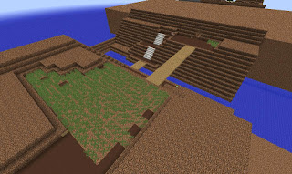
The eastern section traverses across a valley running along the foothills of Mt Coronet. Despite the grass in the screenshot below the only grass in the finished product is tall grass right by the border of Eterna City.
A narrow wooden bridge with no railing connects both sides of the valley.
And that's all there is to it really.
MT. CORONET (Northern link)
Mt Coronet is the link from the western side of Sinnoh to the eastern side. The northern link provides access to both sides of route 211 and if you head north while inside Mt Coronet you will be on your way to Snowpoint City.
The logistical idea was to fit the full interior in 2:1 scale in the narrowest width as possible. Though later I discovered that it would cause all sorts of problems later on. Problems such as misaligned routes and cities on the eastern side as everything constructed serves as a reference point.
The northern link of Mt Coronet is finished. There are four access points, one in each direction. But once this part is complete only two will lead to somewhere.
ROUTE 211 (Continued)
The beginning of the eastern side of Sinnoh. This side of route 211 also measures 64x64 blocks making it exactly the same size as the western side.
The route is also situated around the foothills of Mt Coronet.
There is only one tree on this route. This has got to be the most 'tree free' update in this series.
The width of Mt Coronet was increased from 58 blocks to 64 blocks wide. The size of the whole regions routes and cities seem to be measures in integers of 16 so 58 blocks just seemed a bit odd. Some padding was added to both sides of Mt Coronet.
MT. CORONET (Southern Link)
The southern link takes you to three places. East takes you to route 207, west takes you to route 208 and north will eventually take you to the Spear Pillar.
The interior is exactly 64 blocks wide. It's a bit more technical inside as there are more stairs, rocks and lakes than the northern link.
After the lakes have been filled, the rocks places and the stairs installed it's time to seal the ceiling.
Ceiling sealed.
ROUTE 208
Route 208 links from Mt Coronet to Hearthome City. It, like Route 211 is situated around the foothills of Mt Coronet.
The route drops down to sea level at the eastern side.
A river and a waterfall flow through the route into presumably the ocean. Three bridges connect three areas all joined together by a central island. The rocks faces have a complicated shape to them and consumed most of the time to make this route.
Trees and grass and a house. It's the Berry Master's house.
And there we are. Route 211 complete.
FINISHED PRODUCT
Western side of Route 211
Inside the northern link.
Eastern side of Route 211.
Looking south.
Inside the northern link looking at the path that leads indirectly to Snowpoint City.
Inside the southern link. It's much more spacious than the northern link.
Currently sealed off but this will lead the way to the Spear Pillar.
Route 208 looking east.
River and waterfall.
On the ground. Just imagine the view once Mt Coronet is finished.
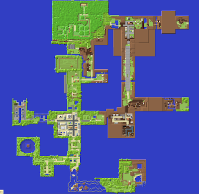
Progress so far..
Stay tuned and subscribe.
PS: Check this project out on Planet Minecraft.
And sample the progress so far by downloading the world here:
If you have any tips for improvement please don't hesitate to share. It would be greatly appreciated. Next: Part 11 features Hearthome City and Amity Square.
After That: Part 12 features Route 209 and Solaceon Town.
And After That: Part 13 features Route 210.
28% Complete.


